
|
This day got off to an early start as I had planned on doing drone photography along the Co. Antrim coast so I was up at 03.30 and by 04.00 I was driving north under a partially clear sky with the pre-dawn stars still on view. I had already studied the models the previous night and was planning on chasing in the afternoon so the plan was simple, coast in morning, inland chasing early afternoon. With moderate widespread CAPE and decent lapse rates heavy showers and a few thunderstorms were expected to form, there was concern about cloud cover and too many showers forming which could kill storm chances later but I would worry about that when the time came. I noted 20 knots of deep layer shear, the first time this Summer that we actually had shear overlapping instability so this took things up a notch, this meant some organization with multicell storms. I watched a spectacular sunrise over the ocean (which I didn't shoot) when the red disk of the sun rose above the flat ocean horizon, the ocean itself was calm and tranquil and sitting out at anchor were two ships, a large bulk carrier and smaller cargo vessel, they appeared black against the red sky as that vivid red disk rose in proximity to the vessels, it was such a cool scene.
I got my drone filming done but it was still too early so I went to Benone Beach where the sun was shinning and temperatures were on the rise even at this early hour, things were indeed looking promising for later, however I hadn't seen any of the convective outlooks as none had been issued yet. I lay back on the seat beside Rhua and continued re-reading 'The Man Who Caught The Storm' about Tim Samaras then I drifted off to sleep for an hour listening to the sound of the surf which was very peaceful. Later the phone rang, it was Nigel McFarland giving me an update, he was hoping to finish up work by early afternoon and planned to chase with me. He read me out the Convective Weather forecast, they had issued a slight risk with flash flooding being the main risk and mentioned that cells would be multicellular lines, they also stated that the north coast was an area that could see the worst rainfall, that was music to my hears as it would save me the trip inland, I would just wait at the coast for convection to form.
After a short cat nap I grabbed a cool drink at the Surf Shop then watched towers building over the sea, things were looking very promising, they were almost at the stage just before thunderstorm formation but after a period of watching they seemed to struggle with soft tops, it looked like a cap was at work. Later we lost all solar heating as the cloud thickened bringing a showery band of rain orientated SW to NE across the country, I suspected this could be a bust day. By early afternoon Nigel had finished up and we met at Articlave to come up with a plan. I managed to get online for a proper look at the models, the AROME was particularly useful showing cells over the Sperrins then N and NE of Lough Neagh, so our target area looked to be Ballymena, Ballymoney, NW or NE Lough Neagh, Portglenone and Antrim, the coast was not the best place to be after all. We examined radar and noticed that the band of rain was breaking up into cells with large red cores, we suspected these would become storms, the back ends looked weak however the forward flanks definitely looked to have the most intensity so the best plan would be to get in front of these cells and watch them approach. The middle and top end of the fragmented band was advancing NE so we aimed for those, our game plan was to drive to Kilrea, find a good vantage point then see what happened from there.
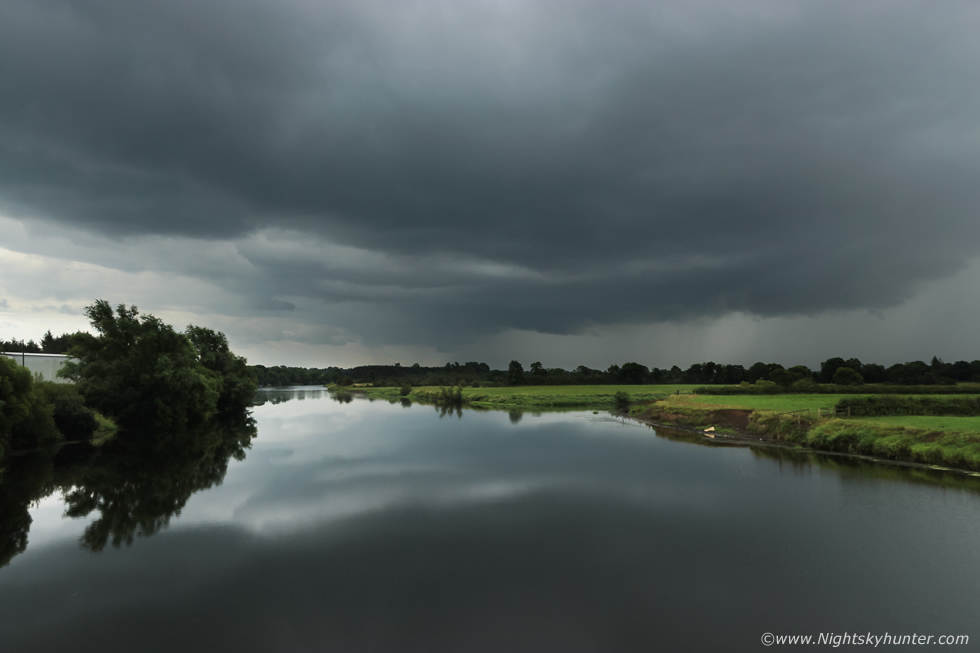 |
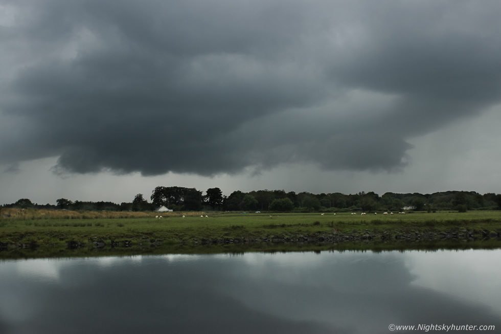
We drove from Articlave to Kilrea then Nigel found a decent spot where we could pull over beside a bridge which crossed the River Bann outside of town. Soon our convective band came into view, it didn't have a lot of structure however the clouds were very dark and it was evident that intense rainfall was advancing our way, we were expecting it to be a rainy mess to be honest. The band took up a large section of sky and was just about interesting enough to take a few images for the record, this was the southern side which was moving straight towards us.
 |
I got into a field adjacent to the bridge to get this capture of the northern side, this seemed to have a bit of a base and the clouds were rising upward which was a good sign, the heavy rain suddenly hit pounding us, we took shelter in the vans then just as we turned the wipers on there was a big crack of thunder, Nigel and I looked at each other and yelled with delight, our plan and target area had worked, we had a thunderstorm. It seemed the storm had just erupted to life with more cracks and rumbles, so we gave chase heading NE and for a good percentage of the time we got stuck under the core, the rain was blinding with significant surface water on the roads and flooding at the sides, this was proper torrential rain, we drove through this unrelenting waterfall as the sky flashed with lightning and thunder rumbled with anger above, it looked like all the lightning was in-cloud.
We kept chasing NE then pulled over in a lay by just as the storm passed and from there we listened to countless rumbles of thunder, there was so much of it we had time to go to the shop then come back out again and it was still rumbling. We knew we could never get ahead of it due its swift speed but we chased after it anyway since it was still active, we had also spotted another storm near Ballymena so we headed in that direction, we just needed a nice place to pull over and watch and this time stay out of the core to search for structure or any funnel clouds. This turned into a mad late afternoon chase, no matter where we drove we couldn't find a decent place to pull over, the main roads were too busy and not practical and the back roads seemed to be constantly lined with trees, poles and houses, we began to get very frustrated, we ended up more or less going in circles then trying back roads which never offered us anything, at one stage we passed the Dark Hedges and where half way to Ballycastle when we pulled over for a break to re-think, we decided we where too far NE and had drifted outside our target area.
 |
The new plan was to head back SW and pick a location with an open view and just let the cells come to us, we had done enough pointless driving already and just burned through a lot of fuel with no images to show for the effort. Then Nigel mentioned the big storms on July 21st when Jude, Colleen Webb and I had watched that evening cell erupt on the hottest day, yes I agreed that could work, I recalled it was called Eden Road outside Clady and had a decent view across fields to the SW and W, so we headed there. Nigel and I where delighted when we arrived, no more driving, a chance to stretch the legs and take in the countryside and have some peace after that frantic afternoon. It was approaching 18.00 and honestly at this stage we weren't really expecting to see much more of interest, nobody said it but we were both thinking just rest a while then head home.
Then we saw two black updraught towers to the W and SW, at first they just looked like average Towering Cumulus but as the minutes passed by they looked better and better and Nigel and I began to take an interest. They really looked to be trying, in fact, they where moving towards us and were getting so tall we were seriously expecting to hear a rumble at any minute. We heard a car pull up, it was chaser Colleen Webb from Portglenone who had just finished work, she joined us hoping for a storm, her timing couldn't have been any more perfect (again). Those two towers had merged into one cell then a long dark base began to form which had us grabbing our cameras.
 |
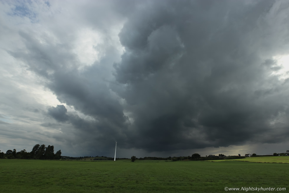
This was the west base which looked a dramatic sight hanging so low over this farm house, barns and silo that we seriously expected a funnel to drop. A multitude of black scud clouds danced, twisted and swirled in a chaotic fashion, we all had cameras in hand and my 100-400mm was sitting in the van within reach if needed, I had both doors wide open to eliminate time wastage if I needed to grab it in a hurry. It was then that the SW side began to get our attention, there was no sunlight and the clouds were very dark, changing from battleship grey to black and through a grey haze a form began to reveal itself, I could see what looked like a curved base then a long striation band above manifested, a few minutes later I realized we were witnessing the formation of a shelf cloud, I hadn't seen a decent one in years so I began to get excited. I said ''guys we have a shelf cloud!''
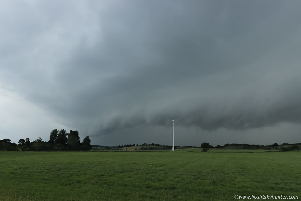 |
Then it came into view about to engulf the wind turbine, it looked to have two tiers with a band in the middle and below chuncky 'teeth' made the formation look menacing, Colleen was cheering, this was her first ever shelf cloud.
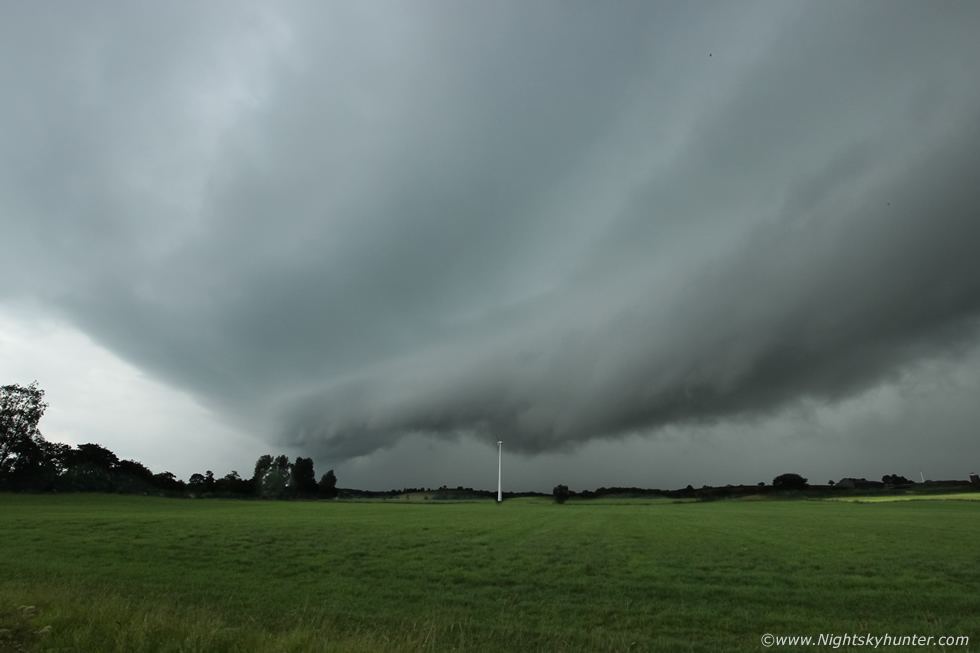 |
It was moving in very fast, I had to switch to the 10mm wide angle for this one, then a big crack of thunder was the icing on the elemental cake and we all cheered with delight.
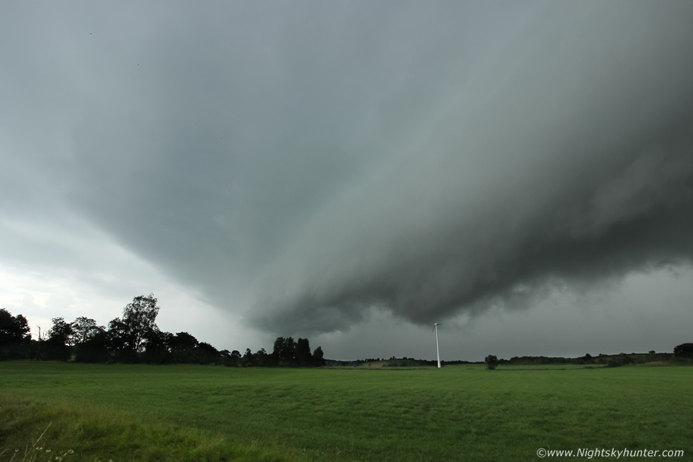 |
So close it was almost on top of us and we could feel drops of rain, seeing this shelf was a real treat but its presence was fleeting unless we made a decision very fast. I said we needed to get ahead of it rite now, it was a risk as it could fall apart but the risk would be worth it in case it got even better, we just needed to get E very fast and stay out of the rain long enough to get another view. Colleen said she knew a good spot, all three of us turned on this narrow country road and headed east, fast, we must have been the only three vehicles chasing in the country. We drove through more heavy rain and I thought I heard more thunder, we were concerned about running into late rush hour traffic, if we got stuck in a que we were finished and Ballymena itself had to be avoided, it had to be the countryside. We put our trust in Colleen, she was driving with intent and we could tell she had a good position in mind, it was just a question if we could make it ahead of this swift moving storm.
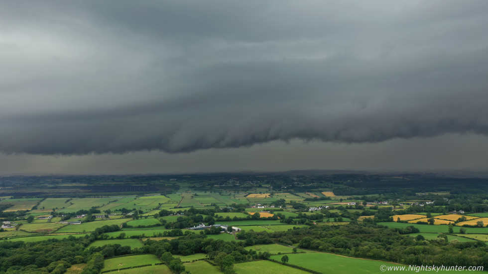 |
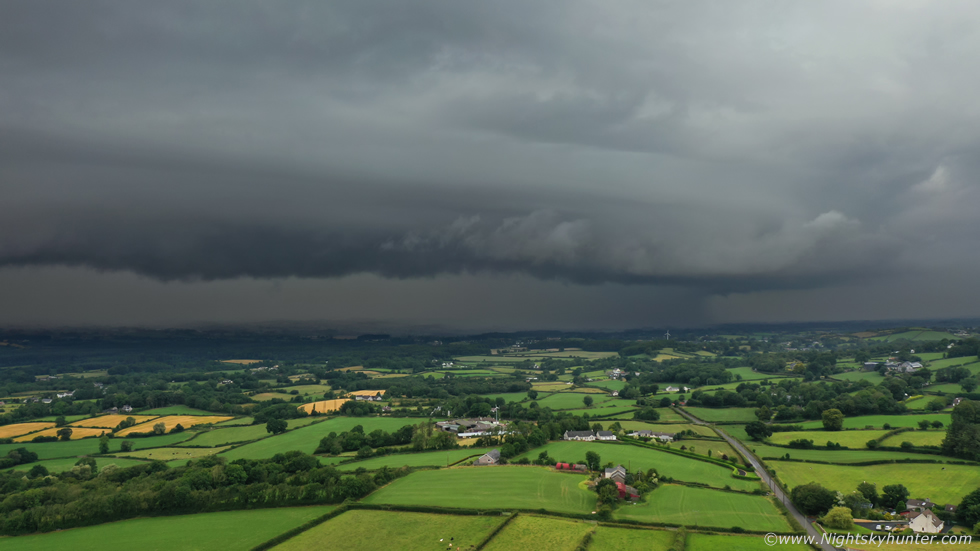
As we drove we managed to get out of the rain and made good progress ahead, in the wing mirror I got tantalizing glimpses of the shelf which looked even more spectacular. Colleen got us into the countryside and onto high ground and we stopped on a gravel lay by with enough room for all of us. We didn't have long to get images, our photography window was narrowing by the second. Colleen and Nigel went to a gate to get images and video, while I decided to get the drone up, I reckoned it was the only tool which could do this moment justice. The Mavic 2 Pro ascended to 60m and via the tablet screen I got a superb view, this shelf spanned across 180 degrees of sky, in other words it covered much of the observable sky and looked like a black dominating monster which contrasted beautifully over the lush countryside outside Ballymena, I began taking aerial stills, this was the mid section.
 |
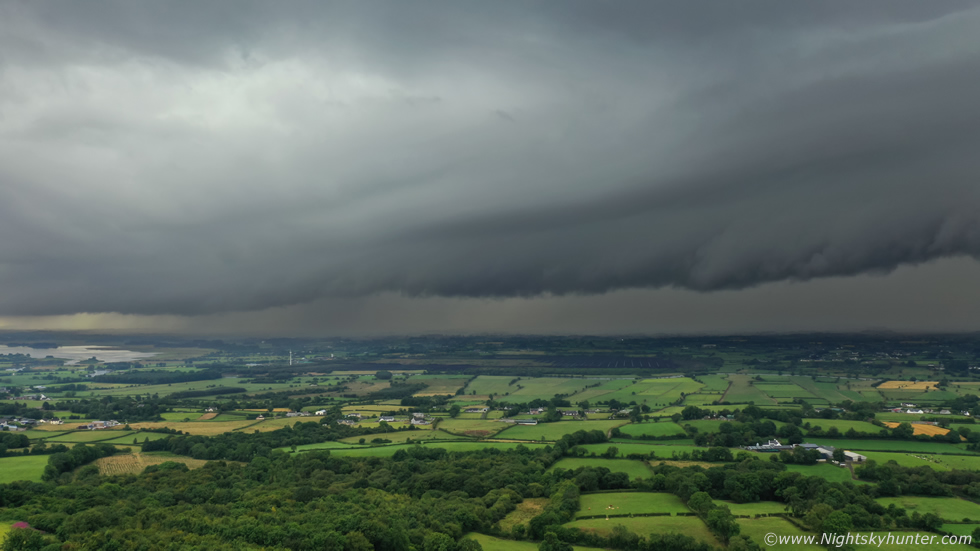
The right section, check out the mid level band across it dividing the shelf into twin tiers, I filmed a cool video sequence with the camera slowly panning across the entire length of the storm.
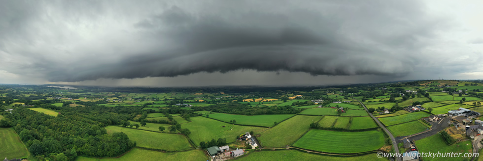 |
We didn't have long before the rain hit us, I decided to try a 180 degree panorama, the drone took these then stitched them together on the spot, the end result was spectacular, I've said it before and I will say it again, the DJI Mavic 2 Pro is an outstanding drone and a great tool for storm chasing.
 |
One more capture with the drone's 28mm wide angle camera, what a mean sight this was.
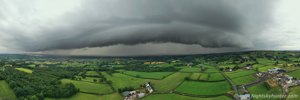 |
I had just enough time for one more panorama, this makes the shelf look very distant but this is just a trick of perspective, it was actually rite on us here and I could feel drops of rain falling. I brought the Mavic down and packed it away just as heavy drops hit the drone, then as if a tap had been turned torrential rain hit us that fast. We gave chase again on our second attempt to stay ahead of it so we followed Colleen once more through back roads and soon we where out of the core once more, we approached a t-junction and Colleen and Nigel took the left option, but I wanted to capture the other side of the shelf so I went right.
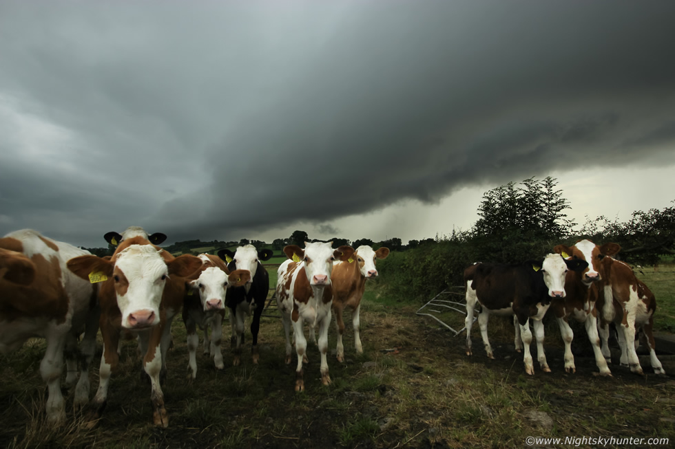 |
I pulled over on a back road for one last look, the shelf was weakening but still looked cool, I was taking images when this herd of friendly Cows came over to see what I was up to so my final image of the day was a shelf cloud over Cows. It was then that I noticed my diesel was very low so I limped back into Portglenone and got filled up. I had lost the others and decided to head home. I cleared the back of the rain and the rear of the cell was lit into warm colours by the low sun and even sported a nice primary rainbow with big anvil overhead. This was the best shelf cloud I had seen since the spectacular Ballyronan shelf in 2009 so I was very happy with how this day had panned out, its always a nice feeling to go back home knowing you have captured structure, my drone video even made it onto the BBC Newsline weather forecast the following day.
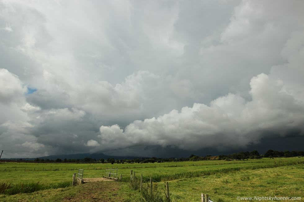 |
The following day brought yet another convective outlook, this time the flow was very slack with no shear so slow moving pulse storms where the main mode of the day. The Met office has issued a yellow warning for thunderstorms and flooding while Convective Weather had issued a slight risk for the same including funnels and weak tornadoes. Solar heating began to work fast on the clouds this day and by 11.00 I was already chasing, I spotted a huge updraught tower over the Sperrins which really impressed me so I chased in that direction. I ended up at Lough Fea where I watched the sky for an hour, I was directly under the base of that tower, there wasn't a breath of wind, the air was warm, wet and humid, it felt like a storm day. I watched convergence at work as clouds met over the lough, the clouds became very agitated, scud lifted swiftly and several areas of clear rotation began to put on a show for me, I was getting close to a funnel cloud, but after a while the outflow came and undercut this atmospheric dance and rotation stopped.
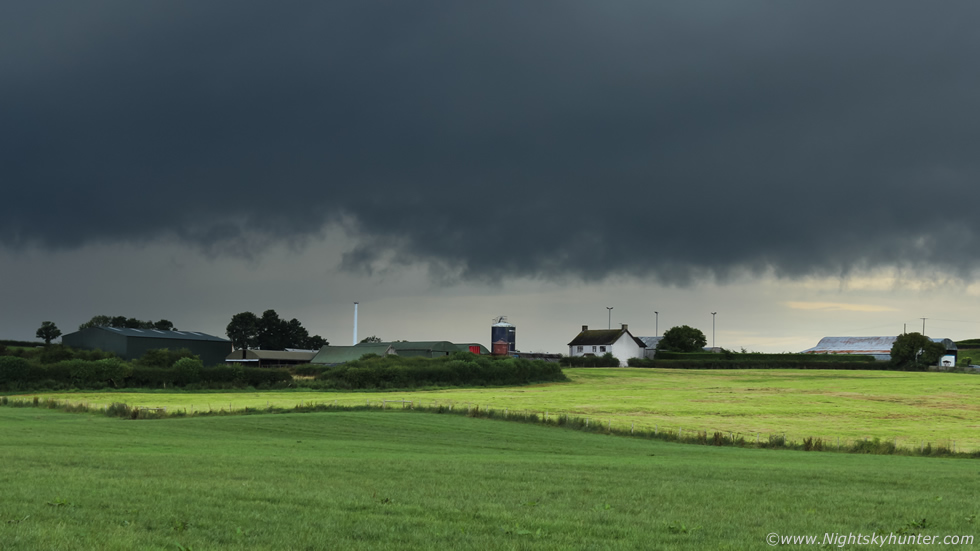
So I decided to head back down to lower ground, I intended to stop in Maghera to get wifi and an update on radar so I took the back road down the mountain towards Draperstown and as a result I drove under the core of that big updraught. My goodness what an experience that was, the torrential rain was incredible and never stopped, the back roads were crazy and as I descended down the steep hill from Lough Fea to Straw a lorry flashed its lights to warm me about something, I mentally prepared myself for the worst, I dropped into a dip and the entire road was flooded, a car waited on the other side refusing to go in, I went on through anyway and the van barley made it, it really was a close one, but we triumphed. I then took the country roads outside Maghera and escaped the core and was greeted by beautiful sunshine. This was the view looking back on that cell towards Slieve Gallion, you can see the edge of the big anvil and the low cloud base, this was a high precipitation beast.
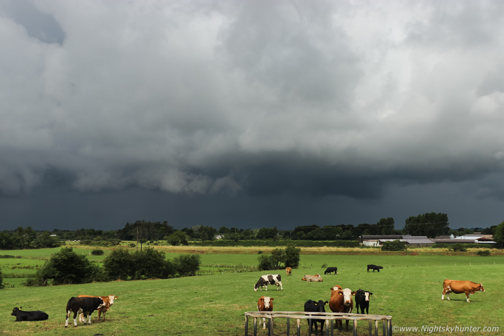 |
I stayed ahead of it and watched the mean clouds pass over sunlit fields with grazing cattle, it was really warm and humid, complete contrast to the monsoon under that core. I watched for funnels for a while then I was back under the core again. I spent the rest of the afternoon on Glenshane Pass checking radar but all the cells had merged into a wet mess so I returned home. I wasn't disappointed, I enjoyed the drive through that rain, the rotating clouds and the dramatic low base over the Cows, and besides, the shelf cloud the previous day had already stole the show so I was happy enough.
Drone sequence of the shelf cloud as I slowly panned the Mavic 2 Pro across 180 degrees of sky, also a short clip at the end from the Go Pro showing the rain core under that same storm. Thanks very much for reading.
Martin McKenna
